Some 30 years ago I heard my father, R.J. Bennett, talk about how some miner wanted permission and funds to dig into the hill side below the flat to get gold, to dig into a gravel bank and draw out the gold with mercury, but prospectors had had not much luck. I had heard my grandfather Dr A.S. Underhill had invested in gold mines. I never suspected it was in these very mines we read about here. Even under the family ranch. The summer of 2002 I began to look into the old gold mines, and this is what I found:
There were 26 shafts. Fife Sommerville had one that went 350 feet into an underground lake of about two acres under a dome ceiling. 1970's there was exploratory drilling. They wanted to know where an ancient, 25 million year old buried river - the Columbia, went. From the top of this tap Allan claimed he could hear water running perhaps 50 or 100 feet below. The tap work, drilling, was by the fence.
Allan said all he got out of it was the water rights to this underground river. His son Garth operates a fish farm fed by springs.
"Ask Art Pollard"
Art said Fife, passed away 2001, was the person to talk to and Fife told him many stories 40 years ago. "Can't remember now, I was ill in hospital and now my memory is gone." Art said this lake must be under Rim Rock, a 100 foot sheer cliff, "I can see it from my window as we speak", 1 kilometer north of the light signal on Wrinkles Face mountain, about 300 feet below the top of the hill.
Kids from Winfield used to go up there and sluice for gold. A cat came up and made a mess and spilled oil so the gold would not pick up. Further in, there was a Welsh miner worked a small shaft. They were small people and did not need much room to squeeze by. There were several fox holes just past the cabins in Fir Valley, a right, then open area, set into the bank. Now covered by logging activity.
First heard of it when 15 in the 1930's.
Once one of the shafts flooded and the mine workers hurried out just in time. A pond above the rocks had drained into the side of the mine. Never heard of anyone killed in the mines. The mines never used any propping up. So would be very dangerous to go in now.
Hall and Ely worked the shafts by wheel barrow. They used a flume of water to run into their sluice boxes lined with fleece. They would then wring out the fleece blanket and pan it. If there was color, flakes of gold, they drew it all together with mercury. Then they squeezed the mercury out with some material then reused it. They kept a small bottle of mercury. They had no family.
Later a mining company out of Calgary hired miners from Byemoor Alberta. They used a 1928 cat that did not have a blade or anything. They used drag lines. Cat could not go into the small shafts. Miners would go down into Winfield to buy groceries and walk back up. They had no cars, nothing, probably lived on $100 a year. Gold was $28 an ounce then and doubt they ever got an ounce. Doubt they ever got the money they put into it. Never heard of any one finding a rich pocket. Never heard of anyone finding any nuggets. One was happy if they just found color, black magnetic sand, or a flake of gold.
Geologists went to work there. They tried to figure out which way the river flowed and where it went to and came from. It was called the "Lost River Gold Mine."
Don McClelland owned Sommerville and Clarke place farms on the Eldorado Ranch in Fir Valley. All gone now, no living relatives.
"In the 1970's did some sluicing with my wife and did get some gold. There was an article which I have from 14 years ago on the old mine." The river bed was dated tertiary, million years ago, and predates recent glaciation. The river has been traced from Cherry Ville - Winfield - Mission (Gallagher's canyon) - Rock Creek (- ?Dry Falls Washington). Same gold in all. The gold had come a long ways, was pounded, some of it into flour gold - gold dust. I found one small nugget. The last claim was worked by a young man in the 1980's. He found bigger nuggets by going down into the cracks and crevices of the granite bedrock.
Ely and Hall worked the mine for 9 years in the south part. The only structure left is an ore bin. The north group did not do so well. They seem to have gotten off the river channel and hit solid basalt rock. This was the Holt family's property.
There were 26 tunnels. They filled with water, then were blasted shut in the 1950's. 4 remain open. One Fife Sommerville worked on has 7" of water. Another goes in 20', then goes down vertically. One other is dry and timbered and another old tunnel goes into the granite bedrock. There are 2 more up in Fir Valley, quite a hike in. On the Eldorado Ranch side there was the Campbell claim excavated back into a cavern laying back from the entrance to Fir Valley off Beaver Lake Road 1k. Now covered by 27 years of growth.
We looked up to the mine area and saw a basalt column. The river was covered by sand then basalt lava flows from Lumby to Eldorado Ranch. The Chinese followed the buried river from Lumby, putting in shafts all along the river bed to Rock Creek. However, mostly Ely and Hall, and Fife Sommerville worked these diggings. We could see 10 or more of these caved in shafts, some 100' feet in or more. We went 50' up to Fife Sommerville's shaft. It was timbered half way into sand or soft sandstone.
For a 100 feet there were no timber supports to another 100' of which the back I could only see a few inches of ceiling because the shaft was filled in with this sand. We were told the shaft went 400' back to an underground lake of 2 acres. From there one could see two shafts the Chinese had dug into the lake. We were told there used to be a draft coming out from there.
We went up 100' above the shaft and looked down. There was a gulch 200' long and 40' deep. We were told the Fife shaft went to directly below the bottom of this gulch of broken basalt rocks. The story is that the water from a pond in this gulch broke through the side of one of the shafts, and the men scarcely escaped. This drained the pond and they were not able to use the shaft anymore because it filled with water.
In the 1970's Union Oil tapped, drilled down, to the ancient river bed to map exactly where the river had gone. Allan MacDonnell Sr could hear running water from the tap pipe.
Above is Holt's property. Just inside the fence is a shaft. At the end of a dead end road there is a knob and a tap pipe. Holt's property faces Eldorado Ranch above, MacDonnell's property faces Eldorado Ranch below.
From the big fir tree in the meadow below looking up is the fence and above this is Fir Valley. There is a cliff running lengthwise which is used for a fence. However, Alan MacDonnel's property is actually some 50' above the cliff.
The hills are riddled with mining tunnels where miners in the 1950's searched for Lost River gold deposit. Glaciers melted to flow into this huge Lost River carrying gold from far up stream. Earth's climate warmed and the glaciers disappear as did the Lost River. Next volcanic activity spread a layer of ash and basaltic lava over relatively flat land to form a cap over the river bed. Lastly, we entered into another ice age which melted 10,000 years ago.
The land buckled and warped under the weight of the ice forming valleys. As the ice receded and the weight lifted, the land flexed to form rifts in the basalt rock and shifted the river bed. There was a small lake in Fir Valley but is now gone.
The settlement of Fir Valley was named for the great fir trees. Silvers Mill opened up the area to settlement. This is the first place Lost River gold was recorded to have been discovered. Louis Clark, the son of home steader Jeremiah "Cap" Clark, fell and dug his heel into some mud and reached down to pick up a $4 gold nugget. Louis Clark wrote on the wall of his cabin by a small hay field, "Cutting some good hay, August 3, 1934...back to school in September." Bill Sly was the last resident of the Clark farm, leaving in 1972. Phil McMacken was the last resident of Fir Valley. He died in 1962.
The Brick House was built from Dukhobor bricks that were transported by horse and cart from Enderby in the 1920's by the Quail family. The Sommerville family took over the house. Lumber prices rose in the late 1920's and the Munson Sawmill began operation above the former Hiram Walker location. John Sommerville and his wife Fieda and son Fife took in men working at the sawmill.
Archie Clark collected nuts from the squirrels in his cabin walls for Christmas. He took them inside for sorting and found gold! the size of a pea. This began a small gold rush in Fir Valley. That spring, 1930, Ray Shimmerhorn, who was boarding at the Brick House, contacted two prospectors from Alberta. The depression had just begun. Prospectors Hall and Ely were in their mid forties. Hall was a small man and preached Sundays in Winfield. Ely was a big man, a singer with a booming voice, and had a temper he directed at Hall. They ran a chalk line down the middle the the cabin, and would not allow the other to cross it. The line even divided the doorway.
No one knows what became of Mr Hall. Ely went on to become an officer in WWII. Neither man returned to work in the gold mine.
Hall and Ely mined quietly for nine years and lived in relative poverty. They found and discarded many garnets. They kept a tobacco tin full of flour gold.
About 1931 John Sommerville began mining gold to the south of Hall and Ely. In 1933, while tunnelling, he hit a large pocket of water. Fife recalled that the ensuing jet of water came out with such force that it washed the gravel out of the mine all the way down to bed rock. "The gold had already been sluiced...it looked as if a large water monitor had been used to wash the gravel."
Fife worked the hillside to see if his father had been on the right track. "There were eight or nine tunnels at one time. But almost all of them were blasted closed by the government in the 1950's. Afterwards you could see the depressions running up the hillsides were the tunnels collapsed." Fife staked a claim in 1959 between his father's tunnelling and Hall and Ely's. Located on one rim of a curve in Lost River, the other rim being located 3/8 of a mile north. Fife said "most of the tunnels did not require cribbing. It was packed into conglomerate that was quite stable." John Sommerville gave up after blasting 60 feet into solid basalt.
Fife said "Hall and Ely took only coarse meshed gold. All the fines were still in the tailings. During the 1950's Mr Paulson reworked those tailings." Fife mined flour gold 350' into the hillside in search of bedrock. "I'd like someone to look for it again...just to see if I am right about it."
Between 1935 and 1936 two men from Calgary, Fox and Richlak of Canadian Colliers, arrived in Winfield. Their ore cars still existed untill the mid-1950's.
In the 1960's Campbell brought in a bulldozer, scrapers and other large pieces of equipment to clear the basalt layer off the the gravel deposit. "They were stripping the land based on platinum assays." Fife said. Platinum is $759 an ounce today, November 2003, forecasted to reach a high of $825 in 2004. The bulldozers pushed the upper hillside away in an attempt to find platinum and gold. They ceased operation abruptly, unlikely to have found any gold.
Shorty Myers, a miner from Nova Scotia, was regarded as the finest of blasters. Shorty was called in to blast rock for the highway around Duck Lake. "He placed the charges perfectly, breaking the rock without moving it an inch."
Fife struggled with Multiple Sclerosis. In the 1970's he dropped a tie on his foot and never returned to his mine. After that, everything was stolen. Only the tractor, which was locked inside the tunnel was left.
Archie Clark discovered and operated the White Elephant Gold Mine above Fintry. Fife said gold was also discovered on the east side of Kalamalka Lake but rattlesnakes scared off the prospectors. In 1988 some tried to reopen the Kalamalka Gold Mine located near Lavington. The Lost River is believed to have flowed all the way from Rock Creek north to Barkerville. --End
Hall and Ely mined on Wrinkles Face. Not the cliff that goes by that name, the protruding, wrinkly, barren, hills beneath. An outfit from Calgary came out to mine the gold but went broke. We used to go to the mines off Beaver Lake Road. Whenever, Hall or Ely found a nugget and did not tell the other they got into an argument and drew a chalk line to divide the cabin. Hall came down to church Sundays. He filled in when the minister was out of town. Ely was bigger than Hall. Lost track of Hall, after the war, WWII. One of their shafts went in 450 feet. Only the openings were shored up with timbers. In the 1950's the government had the shafts blasted shut. There are long gullies there now, all that's left of the mines.
There were many mine shafts. They did find gold in varying amounts. The families up in Fir Valley supported themselves by mining for gold. There should be some family members still living who could tell you about the mines.
"A new section of country has been developed during 1876, namely the mines of Cherry Creek and Mission Creek in the Okanagan District." This is the same, "Lost River", ancient river bed. "20 men are employed on the former and 12 men on the latter Creek, the yeild on Cherry Creek being $4 to $5 a day, and on Mission Creek $3 a day. $8,000 has been taken out." December 18th, 1876.
Pay dirt on Cherry Creek yeilds $6 a day to the hand on the benches about 60 feet above the creek. Two men took $540 of dust out over one month. "There are several companies of Chinamen at work," Gold was discovered on the headwaters of Kettle River. 1877 "Above a certain place on this (Mission) creek, no gold is found" that is where this ancient "Lost River" bisects Mission Creek 70 feet above in the bank. At Cherry Creek there are some 30 whitemen and 15 Chinese at work. Since discovered in 1876 the Cherry Creek and Mission Creek have produced a large quantity of gold in proportion to the labour expended. November 1879.
"Messrs L. Blond, Basset and Linnell ran a tunnel into the hill-side 70 feet which has been paying $5 to the hand. Mr. Narcisse Duteau is also working a tunnel; he is now in about 100 feet, and has two side drifts of about 60 feet, and has good pay all the time." "About a month ago a party of prospectors found a good prospect of coarse gold on the Salmon River, emptying into Shuswap Lake.."
December 1887: "During the summer I visited Cherry Creek and tested some of the Chinese claims by panning out several pans of dirt, and satisfied myself that they were very slightly remumerated for their work after stripping from 20 to 25 feet of bank to get down to the pay streak, which is about four inches from bed-rock. Seven white men have been prospecting -- running tunnels trying to find the lost lead." "Mission Creek Hydraulic Company did considerable prospecting this summer, but found that the hydraulic apparatus was insufficient."
December 1888: "The prospects on this creek are looking up, both in placer and quartz mining. The Chinese (in all about 40) have done much better this summer."Mission Creek: "Very little has been done, only a few Chinamen, with one or two whites, making a bare subsistance." Rock Creek: "I was very surprised to find such a well-constructed little mining town, called after the discoverer, 'McKinney'. I found the mines (ore?) to be very rich." 1889: "At the mouth of Rock Creek there are about six whites and twenty Chinese working, taking out small wages."
The Chinese placer mined gold for thousands of years: "In Yu's 8th year, in summer, it rained gold in the capital city of Hea." 2200 BC Chinese Classics III, Bamboo Books, p.118
The Lost River dates from the Tertiary Period from before 24 million years ago. From 65 million years ago almost all animal life died out because of both a large meteorite and massive volcanic activity. Therefore the earth got very cold and there was very little oxygen to breathe. This river was as large as the Columbia river is now. BC was a very different place then, you would not have recognized it. The Okanagan Mountains were higher than the Rockies are now. Nearby Black Mountain volcano covered the riverbed in 60 feet of basalt lava. Many glaciations carved out the hillside, leaving only pockets of the original riverbed.
In this area, east of the Okanagan Valley fault zone, sedimentary and volcanic rocks of the Devonian to Triassic Harper Ranch Group are in probable fault contact with metamorphic rocks. Middle Jurassic granitic rocks of the informally named Terrace Creek batholith intrude the older rocks. Eocene Penticton Group and Miocene Chilcotin Group volcanic and sedimentary rocks cap areas of older rock.
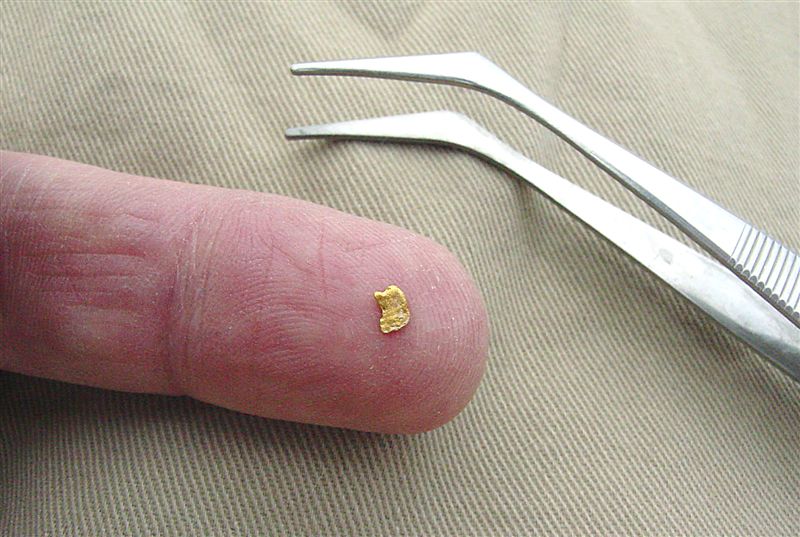
The basal, partly cemented, well-rounded, quartz pebble gravels of Miocene fluvial deposits host placer gold mineralization. The fluvial deposits unconformably overlie gneissic rocks, amphibolite, granitic rocks and/or Early Tertiary volcanic rocks. The Miocene sediments are commonly overlain by Miocene plateau basalt flows. The gold is pure (850 fine), of a reddish colour, and is found as flattened pellets up to 2 millimetres in size, with some very fine gold reported. Garnet and a little magnetite occur with the gold. The fluvial deposits, including 082LSW019, 72 and 142, are estimated to cover a 5000 by 1550 by 60 metre area.
By 1936, exploration drifts of 107 and 52 metres had been completed. Between 1933 and 1945, a total of 2330 grams of placer gold production (75 ounces = $30,000 at $400 an ounce) was reported from the Winfield camp (includes 082LSW019, 082LSW072 and 082LSW142) (Bulletin 28). (Reported gold production usually is a minimum. The reported gold often was less than the actual production because the miners did not want to pay the taxes.)
Further development in the lower drift was done by Eley, Hall, and others on the old high channel to the east of Woods Lake between Vernon and Kelowna, and some placer gold recovered from near bed-rock. This is a very interesting occurrence of an old high channel possibly a mile or more long and a similar distance across, and from 200 to 300 feet thick, lying on a monzonite bed-rock and covered by lavas. The commercial possibilities depend upon whether or not a sufficient thickness of gravel can be found containing gold values. Up to the present a thickness of at least 25 feet is indicated. The ground in the two tunnels - one, 130 feet long, with a winze 25 feet deep at the end of it, and the other, 50 feet below and approximately 300 feet long, about 7 feet above bed-rock - encountered well-rounded partially cemented, mostly quartz and quartzite pebbles, from which comparatively coarse placer gold has been taken. The bed-rock appears to dip very gradually to the east and north.
The section in which the work has been done has undoubtedly been subjected to severe stress from the overlying lavas, and possibly the gravel and bed-rock may not be in place.
Development of the Woods Lake old-channel placer-ground, located about 800 feet above and and 1 mile east of the lake, was continued by Hall and Eley, and also by a syndicate of Kelowna men who drove a 100-foot drift on the Stuart lease about a mile north of Hall and Eley's ground (see Annual Report, 1933). A considerable amount of coarse placer gold has been found in the former workings. On Mission, Cherry, Siwash, Trout, and Deep creeks, "snipers continue to earn a living.
The Woods Lake placers appear to offer possibilities to capital.
Winfield (Woods Lake) Placers - Development and testing of the Winfield placer area was undertaken in the fall of 1935 by the West Canadian Collieries, of Blairmore, Alberta, under the management of J.A. Brusset and local supervision of D.J. McNeil, geologist. A crew of ten to twelve men has been employed and the working-adit on the Hall and Eley lease is being driven easterly to determine the width of the old channel and the gold values therein. A Denver mechanical gold-panning machine is being used to wash the gravels taken from the adit.
Further placer-work was also carried out by individuals and small syndicates on Mission, Cherry, Siwash, Troup, and Deep creeks.
Gold bearing gravels have been found high up on the eastern hills flanking Woods Lake. These gravels are at an elevation of about 3,000 feet and are known to extend from near Clark Creek north for a distance of about 2 miles. In the southern part of this section, near Clark Creek, sparsely-wooded ground slopes gently, but is irreguarly broken by small dry ravines and short deep rises; bed-rock outcrops are not plentiful. In the central and northern parts the gravels are found on wooded slope cut by a few small gullies which are dry for all but a brief period in spring; 100 or more feet below is the steeper Wood Lake valley-side.
Immediately above are bluffs of basalt which rise in steps to plateau ground on the east 200 to 500 feet higher. The gravels are to some degree water-bearing and occasional springs occur at and near the lower edge of the line of outcrop.
From the small settlement of Winfield, 14 miles north of Kelowna, on the Kelowna-Vernon Highway, a branch road leads to a sawmill camp on Clark Creek, a distance of 4 miles; a rough side road 1 mile in length from near Clark Creek leads nearly to the chief site of activities, the Hall and Eley leases. From the end of this road a trail follows north along the hillside.
Bed-rock is a grey, commonly porphyritic rock which varies between granite and granodorite. Uncomformably overlying the granite is Tertiary basalt in a number of superimposed flows, 20 to 40 and more feet in thickness. Associated with the basalt are poorly consolidated tuffs which occur beneath the lowermost and between the some of the succeeding flows. Considerable deposits do exist, particularly at and near the south end of the occurrence of gravels, but exposure are insuffient to allow of accurate determination of character and distribution of these deposits.
The unconsolidated, gold-bearing gravels, lie above the weathered bed-rock and beneath the lowermost basalt flow. Consequently, although the precise age of the basalts is not known, the graels are Tertiary in age. They are definitely stream-lain and represent part of an ancient drainage system. The graavels are strikingly different from andy others in the genearal region; They are very light in color, are well rounded, and are composed of highly resistant large cobbles, although boulders in excess of 2 feet are occasionally found.
The commonest material is a white or nearly white quartzite of fine grain, much of which clowely resembles vein-quartz; other materials include granite, syenite, diorite, quartz, obsidian, gneiss. Concentrates from panning contain abundant garnet but very little black sand. The gold is quite pure, of a reddish color, and is found a flattened pellets of match-head size and smaller. In some localities much of the gold is reported to be very fine and in others it appears that pellets predominate.
Little is definitely known regarding the course and dimenisions of the channel. It is very probable that it flowed from north to south, because there is to the north a source for the white quartzite pebbles and none to the south for many miles; differences in elevation must not be relied upon too strongly, because some tilting of the land surface may have taken place in Tertiary times and also because there may be tributaries, as yet unrecognized as such. The base of the gravel at the Aitkens and Staples lease on the north is about 200 feet higher than at the Hall and Eley leases.
Gravels are found at interavals from near Clark Creek, in an arc round the side of the hill, north for 1 1/2 miles, and again at Aitkens and Staples lease, south of which the channel has been eroded away or remains obscured farther to the east - in any event a fairly sharp bend is indicated. At the south end either the hillside follows closely a bend in the former stream or else the channel is several hundred feet wide.
The channel is nowhere exposed in cross-section, so it is not known whether it is simple or complex.
The channel has been faulted, roughly parallel to the line of basalt cliffs, and the outer or western segment has dropped down.
The Tertiary channel was undoubtedly covered by basalt-flows. A tunnel driven on th Eley lease below the cliffs definitely proves the existance of gravel beneath basalt.
The base of the gravel is here covered by coarse talus, just west of which is a ridge of basalt which is an erosion remnant of the down-dropped fault-segment. Drifting in three places in this locality and also on Aitkens and Staples lease is reported to have started on bed-rock, which dips easterly, then has encountered un upswing 150 to 200 feet in and has ended in blocks of basalt, seemingly dragged down by the faulting, and which lie amongst gravels on or close to bed-rock. The faulting, of less than 100 feet displacement, has apparently been quite extensive and roughly paralells the contour of the hill; open cracks in the basalt are found a few hundred feet back from the line of cliffs on the Summerville lease.
At the southern end of the known occurrence of gravels, erosion, and deposits of glacial materials, has obscured the distribution of gravels and the relation of these to bed-rock.
Of the many short drifts, test-pits, and open-cuts erratically distributed throughout the 2 miles of ground, some are in gravels, some in tuffs, and some in glacial materials or over-burden. Several drifts, 100 to 350 feet in length, have been drived both by individual and company endeavour, and of these only two are now accessible. As detailed descriptions of workings seen by the writer would be incomlete, none will be attempted, more especially because much of the evidence given by the workings is of doubtful value.
In the fall of 1935 J.A. Brusset, general manager of Western Canadian Colleries, Limited, of Blairmoore, Alberta, obtained an option of approximately 1,400 acres of leases. Work, under the direction of D.J. McNeil, included two drifts on the Eley and Hall leases, as well as surficial exploration at scattered points; the option was relinquished June 30th, 1936. In the first drift, 350 feet long on the Eley lease, water-filled at the time of the writer's visit, testing on the bed-rock throughout returned disappointingly low values. In the second drift, 170 feet long on the Hall lease and at a height of at least 10 feet above bed-rock, the gold content of the gravels was insignificant.
The writer is unaware of results obtained in any of the other workings, and he did no testing.
Both reported recoveries and the clean, open character of the gravels seem to preclude the possibility of gold occurring in paying quantities except at or close to bed-rock; if the channel is a single trough, gold is to be expected within that trough; but, if complex, gold may be concentrated in any one of the several troughs or gutters.
The shallow troughs in bed-rock encountered in the longer drifts on the Hall, Eley, and Aitkens-Staples leases have not been proved to be cross-sections of the actual channel and might conceivably represent a side-channel or channels.
Testing beneath the undisturbed basalt has not been attempted except by one short drift, now caved.
The lack of conclusive information obtained by the already considerable amount of work done indicates that if the channel is to be proved in cross-section and thoroughly tested, a large-scale programme will have to be undertaken. Before underground work is contemplated an accurate contour map should be made of the entire stretch of ground, showing all geological data in detail; some shallow test-work might then be done to advantage, and finally some point of attack chosen for drifting. There is no site without its drawbacks, but at some place on the Eley lease below the cliffs, in unfaulted ground, a drift would perhaps be able to prove the eastward extent of the gravels. Bed-rock is not exposed here, and 100 feet of more of shafts would have to be sunk to bed-rock.
Such a programme would necessitate considerable capital outlay and be warranted only if considerable ground was owned or controlled.
There is no basis at present for estimation of position, extent, or value of maximum gold concentrate in these gravels. It is to be hoped that prospecting farther afield, to the north, may throw more light on the problem and that some point may be found where the channel may be more easily and cheaply explored in cross-section.
Photos by Jim Moody and Andrew Bennett
Old claim stake 1992, Home Stake Inc.:

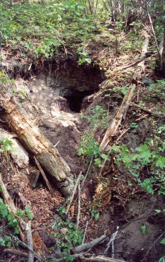


Collapsing in river sand and water seeping along the granite surface above and down this shaft to this puddle. Above the granite is the old river bed. Generally there is no gold there except where the channel moved fast. Thus the exploratory tunnel under the river bed surfacing to mine for gold. Looking up you will see a 15 foot vertical shaft with wooden rungs set in the rock to climb up. The tip seemed to be solid granite still.
Perhaps river bottom was reached and showed no gold or an underground lake was breached and water forced the miners out, the puddle beneath may attest to this.

At this end of the tunnel, looking up you see these ladder rungs. Perhaps this reaches the bottom of the river bed. Certainly close enough to leak water to the puddle below, possibly to drain water from the shaft above. Was there no gold here? I do not know why the miners stopped here:

River sand, a mine shaft was dug into the river bed on top of the granite and a spring flows out. Both the tunnel above and this caved in shaft almost touch, as if the miners were trying to drain off the water or meet at the river bottom to get the gold:


Large Iron rocks found near the bottom of the river bed.

This tunnel goes down into the granite. You can see the river gravel above the granite. In some places gold flakes were found at the river bottom in the cracks on the surface of the granite. But here the river bottom appears to be several feet above the granite. There is a granite tunnel further in but is filled in. This tunnel goes in 50 feet more. I have been to the bottom and there is nothing there. They must have blasted far into the granite and when the crumbled granite settled it left this gap along the top.

A spot light from this position shows 30 feet more of tunnel. The tunnel is sloping down. I went to the bottom, it comes to a dead end. The miners must have simply blasted a long ways into the granite hoping to scrape away at the gold bearing river bed above. The 10 inch gap at the top of this rubble is just the result of the blast that shrunk the broken rock below.

These protruding logs must have held up the ceiling of the shaft:

Most northern shafts on Eldorado Ranch:

The tailings indicate the mine shaft must go into the hillside another 30 feet:

Radioactive reading is only from pink potash:

Basalt columns in lava "cap" above river gravel:

Fife Sommerville's upper mine site, goes under Eldorado Ranch and down eight feet to bedrock:

Upper tunnel entrance. Mine dug by Fife Sommerville in mid 1960's. 30 years ago, kids explored these mine shafts and found dynamite and blasting caps. Their fun ended when their uncle caught them.

Basalt boulder field, collapse of cliff face. Shafts into bedrock on left, same bedrock as 100' below. There was a small lake in this depression which drained out through an old mine shaft. Perhaps the one described above where the miners escaped just in time:

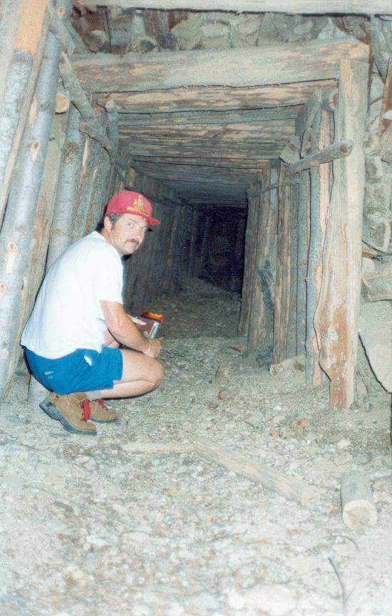
Tunnel that Fife Sommerville and retimbered. Photo 1977:

Man crawling out of tunnel in winter:

Ore bin to collect gravel and water:

Jim's diggings at Winfield Mines, 1980's:

Tunnel with vertical shaft. Drops eight feet to bedrock:

Blocks of stone cover the entrance to this shaft about where Shorty Myers dug a narrow 3 foot wide and 30 foot long horizontal shaft, between the hard pan of the river and the gravel. He recovered enough gold to fill a small bottle of at least a few ounces:

50 hours of sluicing, $100 in gold at $700 an ounce:


Miner's cabin 1963

Jim Moody at partial collapsed tunnel entrance.

Tunnel length 60 feet. No river gravel found - solid rock.

Hard rock tunnel. No river gravel found.

Tunnel in rock - ends at basalt lava face.
End of tunnel - hard rock.

© 1998 - 2016 Andrew Bennett. All Rights Reserved.